 |
-
Scenic Drives Gold Belt National Scenic Byway
Situated on the Gold Belt National Scenic Byway, Victor is at the junction of railroad routes which serve as today's highways. The Phantom Canyon Road is one of the most scenic and historic drives in Colorado. The route, which follows the 1890’s bed of the Florence & Cripple Creek Railroad (F&CC), increases in elevation from 5,500 to 9,500 feet and offers the chance to see a wide range of plants and wildlife in their natural setting.
The F&CC was built in 1894 as the first connection from Florence to the goldfields of Cripple Creek and Victor. The unique bridges and tunnels offer a visual link to the area's historic past.
Following Eight Mile Canyon, the railroad hauled gold ore from the mines of Cripple Creek & Victor to processing mills in
Florence from 1893 to 1912. The F&CC was a popular passenger route as well, making a social connection between the gold fields and Florence and Canon City.
The F&CC was shut down July 12, 1912 when a huge flood roared down the canyon, ripping out track and 12 bridges.
The route was opened as an auto road in 1918 and today is part of the Gold Belt National Scenic Byway. The old Steel Bridge, two tunnels, and other historic sites are part of the drive.
The Midland Terminal, which ran from Colorado Springs up to Cripple Creek, opened July 4, 1894 three days after the
F&CC arrived. Four passenger trains per day ran on the tracks and gold was hauled to a processing plant on Colorado Springs’ west side.
The railroad, which is now Highway 67 from Divide to Cripple Creek, closed in 1949 when it was no longer necessary to haul gold down the mountain for processing.
Today the Cripple & Victor Narrow Gauge is the only remaining railroad trip.Railroads were the lifeline of the gold mining district in the early days. Three railroads serviced this area, including the Short Line, or the Colorado Springs & Cripple Creek District Railway. The Shortline was the shortest route from the goldfields to Colorado Springs and operated two passenger trains each way daily starting in April of 1901.
The 46-mile route cost over $4.5 million in 1900 value and was paid for by wealthy mine owners. Over 220 box cars and 60 ore cars brought ore from the Cripple Creek and Victor mines down the mountain to the mills in and around Colorado Springs.
During the summer it is said that over 50,000 tourists traveled the route, one of them was Theodore Roosevelt, who proclaimed “This is the ride that bankrupts the English language!” Service on the route ended in 1920. In 1924 the road was opened as the Corley Mountain Highway, operating as a toll road until 1939. Later it became Gold Camp Road.
The Gold Camp Road winds from Teller County 81 north of Victor down the mountain canyons to Old Stage Road near the Broadmoor in Colorado Springs. A tunnel in the last leg of the route washed out in the mid 1980s and that portion of the original road is routed to the Old Stage Road - and is open to Colorado Springs. The road is maintained, though can be washboardy and in winter may require four-wheel drive or chains. The scenery is spectacular and includes towering rock formations, overviews of Colorado Springs and in the fall, brilliant gold aspen stands.
The best way to find Gold Camp Road is traveling from Gillett south on County Road 81 or from Victor north on Teller County Rd 81 - the intersection is marked with a US Forest Service sign and a directional map sign.
The Road to Skagway
Skaguay Reservoir is a pristine mountain fishing spot and hiking opportunity. From Victor, take CR 81 to Phantom Canyon Road and drive about .5 miles to the left turn to Skagway Reservoir.
Arequa Gulch Bridge
Just to Victor’s west on Highway 67 you will cross the highest bridge on the Colorado State Highway system. The bridge across Arequa Gulch was built in 2000-2001 as part of a highway realignment project to accommodate the expansion of the Cripple Creek & Victor Gold M
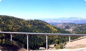 ining Company’s (CC&V) valley fill facility. CC&V financed the design and construction.
Completed in just 11 months, the $18 million realignment project is one of the largest highway projects in the state to be financed completely with private dollars.
The new roadway is 1.9 miles long, replacing a 1.8-mile segment. The most spectacular part of the project is a 1,218-foot long bridge over Arequa Gulch. The bridge, which is 250 feet tall at its highest point, is the tallest bridge of Colorado's 8,479 bridges on the state highway system. The bridge provides travelers with unparalleled views of the Sangre De Cristo Mountain Range.
A portion of the project also involved building a scenic pullout area that enables travelers to view the mountain range and the valley far below. These are views which have never before available from the highway. At the pullout is the trailhead for the Little Grouse Mountain Tail, a project of CC&V, interpreted by the Southern Teller County Focus Group as part of its Trails of Gold project. The trail winds up the mountain to a summit with a 360-degree view of the western and southern mountains as well as nearby mountaintops.This is ZStudios website. Copyright 2012.